


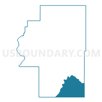
Voting District 9, Cherokee County, Oklahoma
About
Outline

Summary
| Unique Area Identifier | 653657 |
| Name | Voting District 9 |
| County | Cherokee County |
| State | Oklahoma |
| Area (square miles) | 65.17 |
| Land Area (square miles) | 59.43 |
| Water Area (square miles) | 5.74 |
| % of Land Area | 91.19 |
| % of Water Area | 8.81 |
| Latitude of the Internal Point | 35.67708770 |
| Longtitude of the Internal Point | -94.88689700 |
Maps


Graphs
Select a template below for downloading or customizing gragh for Voting District 9, Cherokee County, Oklahoma


Neighbors
Neighoring Voting District (by Name) Neighboring Voting District on the Map
- Voting District 10, Cherokee County, OK
- Voting District 2, Adair County, OK
- Voting District 207, Sequoyah County, OK
- Voting District 208, Sequoyah County, OK
- Voting District 209, Sequoyah County, OK
- Voting District 22, Cherokee County, OK
Top 10 Neighboring County Subdivision (by Population) Neighboring County Subdivision on the Map
- Vian CCD, Sequoyah County, OK (8,077)
- South Cherokee CCD, Cherokee County, OK (6,388)
- East Cherokee CCD, Cherokee County, OK (6,153)
- Sallisaw North CCD, Sequoyah County, OK (4,858)
- Stilwell West CCD, Adair County, OK (4,845)
Top 10 Neighboring Place (by Population) Neighboring Place on the Map
- Tenkiller CDP, OK (633)
- Evening Shade CDP, OK (359)
- Dry Creek CDP, OK (227)
- Flute Springs CDP, OK (130)
Top 10 Neighboring Elementary School District (by Population) Neighboring Elementary School District on the Map
- Keys Public Schools, OK (4,534)
- Tenkiller Public School, OK (1,475)
- Greasy Public School, OK (1,014)
- Marble City Public School, OK (872)
Top 10 Neighboring Unified School District (by Population) Neighboring Unified School District on the Map
- Tahlequah Public Schools, OK (21,386)
- Vian Public Schools, OK (4,716)
- Braggs Public Schools, OK (1,055)
- Cave Springs Public Schools, OK (677)
Top 10 Neighboring State Legislative District Lower Chamber (by Population) Neighboring State Legislative District Lower Chamber on the Map
- State House District 2, OK (37,808)
- State House District 4, OK (37,367)
- State House District 86, OK (36,615)
- State House District 15, OK (35,338)
Top 10 Neighboring State Legislative District Upper Chamber (by Population) Neighboring State Legislative District Upper Chamber on the Map
Top 10 Neighboring 111th Congressional District (by Population) Neighboring 111th Congressional District on the Map
Top 10 Neighboring Census Tract (by Population) Neighboring Census Tract on the Map
- Census Tract 9783, Cherokee County, OK (6,388)
- Census Tract 301.01, Sequoyah County, OK (4,858)
- Census Tract 3768, Adair County, OK (4,845)
- Census Tract 9782.02, Cherokee County, OK (3,256)
- Census Tract 302.01, Sequoyah County, OK (2,568)
Top 10 Neighboring 5-Digit ZIP Code Tabulation Area (by Population) Neighboring 5-Digit ZIP Code Tabulation Area on the Map
- 74962, OK (5,092)
- 74451, OK (4,283)
- 74435, OK (3,185)
- 74471, OK (1,800)
- 74931, OK (1,411)
- 74427, OK (1,383)
- 74945, OK (497)